
Wildfire conditions continue to worsen over the state
Drought Index
An upper-level ridge of high pressure is building yet again over the southern plains, this time centered over OK and N TX where surface air temperatures will reach 108-113 degrees over the next few days. Locally SE TX is sitting at the base of the ridge and we will “only” see actual air temperatures in the low 100’s however heat index values will reach 107-112 during the afternoon hours which is good enough for another heat advisory that starts tomorrow and will likely last much of the week.
With strong subsidence in place from the ridge aloft, little to no rain is expected. The high will give a bit of ground on Friday as weak upper-level low moves inland over S TX from the Gulf. This will be the best chance of rainfall this week, but with moisture generally lacking, thinking maybe 20% is about the best we can get and that may be generous. Highs will remain in the 99-103 range for the entire week into the weekend.
Fire Weather:
The high heat values and dry conditions are starting to materialize in aggressive wildfire activity. Today saw a significant increase in fire starts and highly aggressive fire behavior. Up to today, the majority of the fires have been in the dead/dried fine fuels (grasses) which tend to be small in size and more easily contained. However, today was the first of fires showing extreme fire behavior with aggressive burning into the ladder fuel loads and crowning (tree top runs).
The Nelson Creek Fire in Walker County (North of Huntsville) burned 850 acres in 3 hours with significant ladder and crown runs. The fire also exhibited pyro-cumulus smoke formations due to the extreme heat being generated and indicating that the fire was controlling the surrounding weather environment. Ground and air crews also reported extensive spot fires due to the crown runs which can easily overwhelm containment lines.
While fine fuel loads have been ready to burn for weeks, it is now increasingly likely that the ladder (medium) and large fuel loads are reaching the point where they will easily burn. It appears that portions of the area have now reached the point where the larger fuel loads have dried up enough that they will readily burn. Another sign that large fuel loads are in stress is the loss of leaves and that has been increasing as the longer-term dryness is now reaching depths of 6-8 inches below the soil surface.
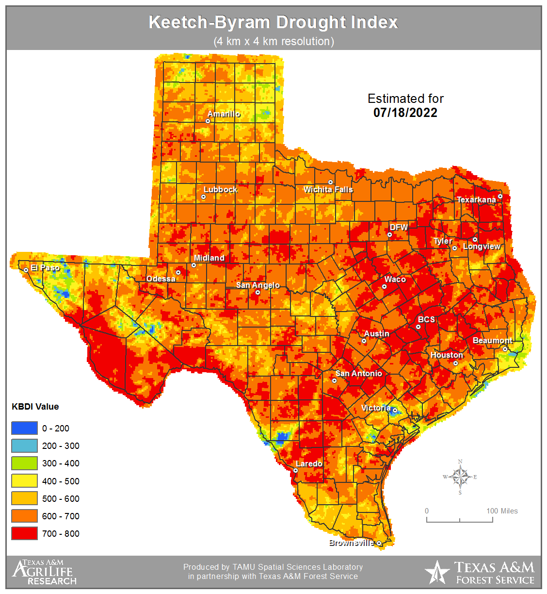
KBDI values range from 600-760 over the region and any value of 700 or above is considered critical for fire weather. Values also correspond to the depth below the soil surface in inches that is completely void of moisture…so a value of 600 indicates there is no moisture within the top 6 inches of soil. The lower down the soil moisture depletes, the drier the larger fuels become.
In addition, to the drying of the medium and large fuels loads, afternoon humidity has been mixing out into the 25-35% range each afternoon, especially inland of I-10 away from the Gulf Seabreeze. This quickly removes any overnight moisture on the fine fuel loads and prepares those sources for quick ignition. Winds today were also a bit stronger than the last few days with 10-15mph and a few gusts around 20mph.
Given the dry fuel loads, low afternoon humidity values, and gusty afternoon winds, fire weather conditions are near critical thresholds over the next 72 hours. By late week winds should decrease some and slightly higher afternoon humidity will help to mitigate starts…but there will be no recovery to the fuel load dryness without widespread rainfall. Maximum mixing heights over the next two days will range from 6,000-8,000 ft over the region with transport winds from the south at 10-15mph and gusts upwards of 20-23mph.
213 Texas counties are now under burn bans the most since the fall of 2011.
Maximum fire safety precautions should be utilized to prevent fire starts and no outdoor burning should occur. Use extreme caution with any open flame. Keep vehicles off dry grass.