Strong to severe thunderstorms and heavy rainfall possible this afternoon over the area.
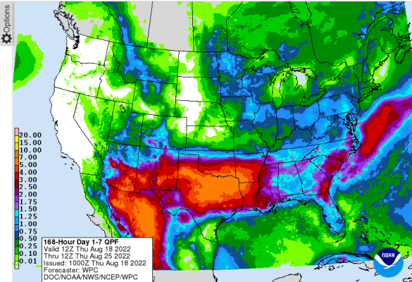
Wet weather pattern in place through much of next week…with drought breaking rainfall possible over a large portion of TX

weather map
This afternoon/evening:
Weak frontal boundary is currently sagging into N TX and will slowly move southward today reaching a line from near Tyler to Madisonville to Georgetown by this afternoon. Air mass south of this boundary is already moist and unstable and with heating will become highly charged with energy by early to mid afternoon. Showers and thunderstorms will develop along the frontal boundary and move southward along with their associated outflow boundaries into air mass temperatures likely in the mid to upper 90’s.
At the same time the sea breeze and bay breeze will move northward away from the coast and Galveston Bay and at some point, these boundaries will collide over the area. Forecast soundings are showing a favorable profile for both heavy rainfall and downburst winds with the storms this afternoon. The setup is fairly similar to last Wednesday. High resolution models are showing various solutions on where the greatest storm threat will be this afternoon with some hints that areas west of I-45 and south of I-10 may have the highest chances of more widespread and consolidated activity. Hourly rainfall rates of 2-3 inches will be possible under the stronger storms leading to street flooding along with gusty winds of 40-55mph.
Storms may continue well into the evening hours with the actual weak front remaining north of Hwy 105 tonight and disturbances moving across the area in the flow aloft. High resolution guidance has continued to show activity lingering into the 11pm-1am timeframe tonight. A weak front will drop toward the coast on Friday, but it remains to be seen how “worked” over the local air mass is from the activity today. Guidance is attempting to develop storms along the boundary again generally south of I-10, but a lot hinges on if the air mass can recover and just how widespread activity becomes later today. Storms could be slow moving on Friday which increases the threat of heavy rainfall with high moisture values remaining in place.
Next Week:
Upper air pattern continues to support an extended period of widespread rainfall across much of TX into next week with yet another frontal system sagging into and stalling across the state and tropical moisture moving northward off the Gulf. Numerous periods of showers and thunderstorms will be likely with some areas receiving significant rainfall over the next 7 days. In fact, rainfall amounts over a large portion of TX may approach the needed amounts to make a large dent in the ongoing drought. Given the tropical moisture that will be in place, heavy to excessive rainfall will be possible, but where and when any flooding concerns become a reality is uncertain.
Gulf:
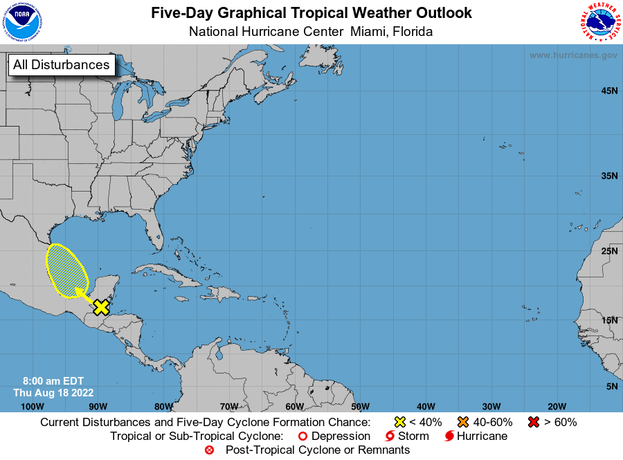
Tropical wave and mid-level circulation that was over the far SW Caribbean Sea yesterday has moved inland over Belize and the southern Yucatan overnight. Vigorous deep convection has developed with this feature over northern Belize into the southern Yucatan overnight and this morning and overall, the satellite appearance looks fairly impressive IR Satellite Loop for Western Atlantic | Tropical Tidbits Belize radar out of Philip Goldson Airport does not indicate any low-level circulation associated with the mid-level circulation and surface observations confirm this. With that said, this feature is highly active with convection, more so than forecast models have been suggesting and yet most show little to no development of this feature as it moves over the southern Gulf starting tomorrow and then NW over the weekend.
NHC has slightly increased the development probabilities to 30% over the next 5 days over the southwest Gulf. We shall see where this feature moves over the warm waters of the Bay of Campeche on Friday and if convection maintains its current cycle and development chances increase some. For now, just an increase in moisture for this weekend with the wave axis moving inland somewhere in NE MX or S TX, but I am not convinced the models are handling this feature well so it should be watched over the next few days once over the southern Gulf.


